ECR and Terra-Treks exploration
of Central Labrador, June 1999
A trip to where the road ends... and then a little
past that.
1 -Start of Trek to Labrador City
A customer of mine once asked me why we were going to Labrador for the 1999 trek. I suppose I should have given him the standard explorer's answer of, "because it is there", but instead I explained to him that Labrador had a lot of the things I was looking for in a trek location. It had to be remote and it had to be rarely done, but at the same time it had to be close enough for us to complete the journey in a reasonable amount of time. Labrador really does fit that mold, yet it is a place that few people know much about, as I found out when I started researching the trip. Labrador is a subarctic land located on the very eastern edge of Canada and it has only a few towns and very few people when compared to its size. It is mostly wilderness with everything from monochromatic barren landscapes to lush green forests with clear pools. It is a province of coastal communities with its expansive interior being largely untouched. A few mining operations and hydro-power plants are located in the interior, but if these did not exist I believe that central Labrador would still be impassable to Land-Rovers to this day. When you view a map of Labrador you see a long coastline dotted with town names of Inuit Indian settlements hidden in fiords and inlets, I assumed it would be much like the Maine coast where I grew up, and I could only imagine what a great site all these small villages would be on a trek with our Land Rovers. Once I started researching the trip I found that no roads existed to these coastal towns. In fact, no roads seemed to exist anywhere in Labrador. A quick check of the atlas showed only one road into Labrador, the Trans Labrador Highway. I thought that surely my US Rand-McNally atlas just didn't cover Labrador, and that the map's scale was too big to show me all the "other" roads that would cover Labrador. A long search of the internet and some phone calls to Labrador gave me my answer. One of the hotel owners from the community of Happy Valley/ Goose Bay gave me the answer I feared, "Yup, only one road in or out, and it isn't very good." The "isn't very good" part was just what I was looking for, the harder the road, the better, but everyone telling me that the road just ended in Happy Valley/ Goose Bay was hard to imagine. I'm an American, there are roads everywhere... to everything. We have tourist stops every 2 miles, you can have your lunch in your car at the drive-thru, we have pay phones that are car height so you can make a call without getting out, you don't even have to get out of your car to get it washed, how could the roads just end? Someone had to be mistaken. They may not have interstates or parkways, but for sure there would be trails that an ECR prepared Land Rover could make with ease, I thought. Well I have to tell you... the road does end. It gives no warnings and no apologies, and if you want to drive a Land-Rover any further North and East in North America than we did on this trip you'd better be ready for the hard stuff. The only things going a lot father then we did are snowmobiles, boats, and airplanes.
Map of Labrador (478K image)
This is a photo essay of our trek. It also can be used as a guide if you care to duplicate our trip.
Our trek actually started in the winter of 1999. If we were really going to go as far as we possibly could, we had to be ready for anything. This meant setting up all the vehicles so that they were in perfect mechanical order, as well as being outfitted to make the trip. This meant a number of long nights installing everything from ARB air lockers to rock sliders, winches to communication equipment and more. The trek was open to anyone who wanted to come along, with the only requirements being some mandatory safety and recovery equipment and some spare parts. We advertised our intentions months in advance, but only a small group of people were hardcore enough to join us on this one. Bill Burtis and his ECR outfitted Defender 90 Station Wagon, and Jason Tyler with his ECR outfitted Range Rover, and Angela Smith were the only ones to join the Terra-Treks/ ECR team.
The driving portion of the trek started an evening in early June. We met at the picturesque Tea Pond Camps in Eustis, Maine as a jumping off point close to the Canadian border. The trip that evening from ECR to Tea Pond was in a driving rain, but our Defenders had been set up to tackle anything so it was business as usual for the trip to Eustis, Maine.
Day 1 started off with a light rain that ended by early morning. After a fantastic breakfast courtesy of Ed Bear (our host at Tea Pond) we fueled up and hit the road for Quebec, the first major turning point in our trip. The group of vehicles consisted of 3 Defender 90 Station Wagons, 1 Range Rover, and 1 coil Rover hybrid.

Tea Pond Camps on Tea Pond in Eustis, Maine.

2 of the ECR/ Terra-Treks Defenders ready for the road.

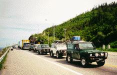
The Terra-Treks team fueled and ready to go: (L to R) Bill, Alan, Angela, Mike, Jason, Ian, Bill B. and Ed (behind camera)
The trip to Quebec is very simple and the scenery along Maine Rt. 27 to the Canadian border is worth the drive in itself, but we had ground to cover. We had made out a rough schedule that would allow us to do the trip in the time we had away from the shop so we were pushing the group for a little more speed. Day 1 was from Eustis, ME to Baie-Comeau, Quebec. This part of the trip was quite impressive with a great view of the city of Quebec and of the St. Lawernce River as we turned northeast and headed up Rt. 138 towards Baie-Comeau.

The architecture in rural Quebec leaves something to be desired, but each village has a beautiful cathedral in the middle of town. When you arrive near Tadoussac, Quebec on Rt. 138 there is a fiord that was obviously too costly to build a bridge over, so they run 2 ferries that shuttle the vehicles from one side to the other. The ferries were both running when we arrived, and the fiord is narrow, so the delay is minimal. It was actually a welcome driving break.
Terra-Treks team waits for the next ferry over the Saguenay River at Baie Ste. Catherine.


The ferries run in opposite directions on the Saguenay River, and the view up the fiord.
The rest of Rt. 138 to Baie Comeau is dotted with small towns that border the St. Lawerence. Whale watching is a big business in some of these areas and the tourist will be able to find whatever he needs, except for people who speak English. Remember this is Quebec, and things are not geared to the American tourist here. Fortunately Angela remembered some French from her travels in Europe, so we had no troubles. Fuel stops start to get a little more spread out in these areas, but 24 hr. fuel is available in Fortestville and Chute-aux-Outardes. We arrived in Baie Comeau in the early evening, and settled in for the night. Baie Comeau is a relatively large town for the area and anything you require would be available there, from food and fuel to hotels and supplies.
The next day was the first "trek" day. We would be leaving the tourism industry, convenience stores, and gas stations behind and heading north out of Baie-Comeau on Rt. 389 for Labrador. Rt. 389 is a very poorly marked turn off a main road in Baie Comeau. As soon as you turn onto it the traffic gets cut by about 80% and you start wondering what you are about to get into if no one is taking the same road you are, but then again that is the point of all this.

The team in Baie Comeau fueled and ready to head north towards Labrador.
Rt. 389 is basically a service road for the Quebec hydro-power dams that are along the rivers in the area. There are 5 major dams here and the workers who work them drive this road very quickly, so don't get in their way, or pick up the speed to keep up with traffic.

The road is good quality, but very windy. It is the type of road that makes you want a Porsche 911 one of our participants stated over the radio.

The first hydro-power operation of the five on Rt. 389 is Manic 1. It is an impressive site.

The downstream view from Manic 1 isn't bad either. The are many small cottages and camps along these waters just outside Baie Comeau, but the civilization quickly gives way to desolation. Except for some small side roads and dam entrances there really is nothing but wilderness between Baie Comeau and Manic 5.
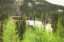
The good quality road ends at the Manic 5 dam. The dam is massive and greats you with an impressive site when you round the valley corner. A massive lake has been man made behind Manic 5 that can be seen for miles as you continue on Rt. 389. You can tour the dam in the summer months, but we were too early in the season for the tour, they start in late June. We scheduled our trip to try and miss the bug season in Labrador, as it is famous for its huge insects. We did miss the worst part of the bug season, but we were looking for cool temps. according to all the data we had on Labrador, but as the summer of 1999 has proven to be a hot one, we were in near 80 degree temps for all but the last few days of the trip, well above the normal temps for the period, that should be around 60 degrees.

2 team Defenders 90s at the foot of Manic 5.

The view behind the Manic 5 dam of the R'eservoir Manicouaagan.
After Manic 5, Rt. 389 turns to dirt and really heads out into the middle of nowhere. At this point the only traffic you will run into is traffic that is coming all the way from Labrador City. There really is nothing between except for those who might be camping or fishing along the way. We saw one or 2 sportsman, the rest of the traffic was trucks carrying goods to and from Labrador. Keep in mind this is the ONLY road in and out of Labrador. It isn't that all the others are over on the interstate while you plod along on this rough, loose dirt road. If they are not on this road it means they have to take the ferry from Newfoundland, or they are not getting to Labrador.

Leaving Manic 5 on Rt. 389, now a much smaller dirt road.

You have to love looking over the hood of your Defender and seeing signs like this! Extreme Danger! That is why we came all this way.

Rt. 389 outside Manic 5, cut right through the wilderness of Quebec.

The road is fairly good, but when the earth is so dry that means dust, and with 5 Rovers pounding the ground that means lots of dust. We had so much dust that the bearings on one of the blower motors on a Defender gave out on the return trip.

This section of the road between Manic 5 and Gagnon has some very pretty rivers that cross the road, and the vistas of the hills and mountains are endless. There is only one gas station along this section of road, and the prices for fuel are very high, so if at all possible you should carry your fuel like we did, so you have enough range to reach the larger towns along the way.

Rt. 389 continues like this until Gagnon, the ghost town.

When you reach the ghost town of Gagnon the road turns back into pavement and is divided for a short section in "town". Gagnon was a mining operation that picked up and moved everything. The only thing left behind were the street, sidewalks and some signs. There are some side streets, a sewer system and more here, but no buildings or services. The only thing you will find are some campers that are left by the sportsmen that must frequent the area. You get the feeling that this is the way things would look after a bomb blast. The tar road is welcome break from road vibration and dust.

We took time to refuel the Range Rover in what used to be "downtown" Gagnon,


and then fueled the 3 Defenders a little further down the road.

We took advantage of the tar road outside of Gagnon to make up some time and get back on schedule. There is a small garage outside of Gagnon. They had no fuel for sale, but in an emergency they might be able to help you. The tar road only last for about 50 miles outside of Gagnon, after that is turn back into dirt. This section of dirt road is a rally driver's dream.

It has hundreds of curves and switch backs, subtle climbs and descents. It crosses a railroad about twelve times and is very loose gravel. Be careful because there are no signals on the railroad tracks and the tracks ARE in use. This is also the section where we almost had a few accidents with oncoming traffic being in the wrong side of the road, so be careful.

The sport drivers in the group had a great time with this section.
This gravel winding section ends in Fermont at the mining operation.

The operation can be seen for miles away and is making a real mess of the environment. I have no idea what they are doing there, but the area looks very desolate, there is a lot of discarded equipment around.

The lake near the operation is bright red... that can't be good. Yes, that is a lake.
After the mining operation the road turns to tar again and we headed for the Labrador border and Labrador City. Just across the border into Labrador from Quebec we came to Labrador City. This city has about anything you need and we stocked up on gas and some other supplies. The start of the Trans Labrador Highway is just on the other side of Labrador City. Our group of Rovers got some pretty long looks from the locals and many people asked us where we were going and about the Rovers. Everyone we came across in Labrador was very pleasant, and eager to help us.
2 -Labrador City to Happy Valley Goose Bay
3 -Mokami Trail
4 -HVGB to end of trek
East Coast Rover Co.
21 Tolman Road
Warren, ME 04864
email: ecrover@midcoast.com